
orto
Orthophotos and Oblique Photos


- Orthophotos of airfields in Oristano
- Orthophoto of a highway junction
- Orthophoto of a highway viaduct
- Detail of an orthophoto of a highway section
- Detail of an orthophoto of a railway section
- Orthophoto with trellis of power lines
- Detail of an orthophoto of the historical centre of Potenza
- Orthophoto of Basento River
- Detail of an orthophoto of Alghero coast
- Detail of an orthophoto of Alghero
- Orthophoto of Santa Maria di Leuca coast
- Orthophoto of Gargano coast
- Orthophoto of a coastal section of Puglia
- Aerial oblique photo of a coastal section of Puglia
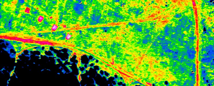
- Colour InfraRed orthophoto of a rural area
Digital Cartography
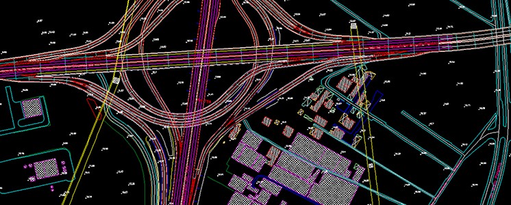


- Digital cartography of a highway junction
- Digital cartography of a highway junction
- Volumetric and vectorial 3D model on orthophoto
- Vectorial cartography on orthophoto
- Planimetry of a power line
- Digital cartography of a power line
- Longitudinal profile of a power line
- Outlook of the power line vectorization
- Stereoscopic rendering of a highway section
- Vectorial cartography of a highway section
- Digital cartography of a highway section
- 3D model of a highway section
- Tridimensional rendering of a highway section
- Vectorial cartography on a 3D model of a highway section
- 3D outlook of a highway section
Satellite Data
_della_città_di_Slatina_in_Romania-cce13ba04a.jpg)
_della_città_di_Sibiu_in_Romania-ba35224ef5.jpg)
_del_Distretto_Arges_in_Romania-2c44fb21bd.jpg)
_del_Distretto_Arges_in_Romania-0a232b2b82.jpg)
_della_città_di_Ramnicu_Valcea_in_Romania-d03f371bcf.jpg)
_del_Lago_di_Monte_Cotugno_in_Basilicata-1d35f1913d.jpg)
_della_città_di_Potenza_in_Basilicata-98dd5da66c.jpg)
_della_città_di_Potenza_in_Basilicata-063719c312.jpg)
_della_città_di_Potenza_in_Basilicata-adbfaa09a1.jpg)
_della_Diga_del_Pertusillo_in_Basilicata-292ae5a38e.jpg)
_dei_Laghi_di_Monticchio_in_Basilicata-1ed16f0337.jpg)
_della_costa_di_Scalea-7cbcff3cfe.jpg)
_della_costa_di_Scalea-c5d233f10f.jpg)
_della_costa_di_Metaponto-28bf9183b7.jpg)
_con_copertura_dell'Etna-b090c84b3c.jpg)
_con_copertura_della città_di_Palermo-6f16ae15ce.jpg)
_con_copertura_della città_di_Bari-ed5da53d21.jpg)
-245a5ee9e5.jpg)
- ASTER satellite image (2001) of the town of Slatina, Romania
- ASTER satellite image (2006) of the town of Sibiu, Romania
- ASTER satellite image (2003) of the Arges District, Romania
- ASTER satellite image (2004) of the Arges District, Romania
- ASTER satellite image (2003) of the town of Ramnicu Valcea, Romania
- ASTER satellite image (2001) of Monte Cotugno Lake, Basilicata
- ASTER satellite image (2001) of the town of Potenza, Basilicata
- ASTER satellite image (2001) of the town of Potenza, Basilicata
- IKONOS satellite image (2000) of the town of Potenza, Basilicata
- IKONOS satellite image (2000) of Pertusillo Dam, Basilicata
- IKONOS satellite image (2000) of Monticchio Lakes, Basilicata
- LANDSAT satellite image (2001) of Scalea coast
- LANDSAT satellite image with CIR band composition (2001) of the coast of Scalea
- SPOT satellite image panchromatic SPOT (1998) of Metaponto coast
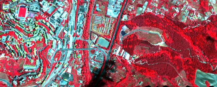
- Analysis of SAR ERS2 satellite data (2002) with covering of Etna
- Analysis of SAR ERS2 satellite data (2009) with covering of the town of Palermo
- Analysis of SAR ERS2 satellite data (2010) with covering of the town of Bari
- Movement speed map of the city of Rome coming from the analysis of SAR COSMO-SkyMed data (2012)
Thermal imaging


- Aerial thermal image of a rural area
- Thermal image of a coastal section
- Thermal image and RGB of a coastal section
- Thermal and in the visible image of a coastal section
- Thermal and in the visible image of a road bridge
- Thermal image of a military area
- Thermal image of a power line
- Thermal image of a volcano
- Software for thermal images processing
Hyperspectral imaging


- VNIR aerial spectral image with CIR band composition
- VNIR aerial spectral image with RGB band composition
- Biotope chart derived from hyperspectral data
- NDVI chart derived from hyperspectral data
- VNIR aerial hyperspectral image related to a coastal section
- Classification of a hyperspectral image related to a coastal section
- Analysis of the radiance based on SWIR hyperspectral data
- VNIR hyperspectral image with CIR and RGB band compositions
DTM | DSM
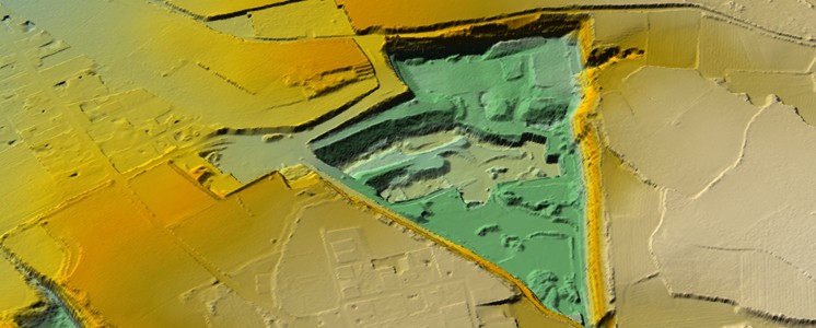


- DTM of an archeological area
- 3D vectorial model DSM and DTM of a river area
- DSM and DTM of a coastal section
- Orthophoto and DTM of a meandering area
- Identification of the slide mass on DTM
- DTM of an inhabited area being at risk of slides
- DSM and DTM of an area being at risk of slides
- DSM and DTM of a Sinni River section
- Hydraulic simulation on high resolution DTM
- 3D model with texture of aerial images of Stromboli
- DTM hillshade of the eruption craters of Stromboli
3D Models
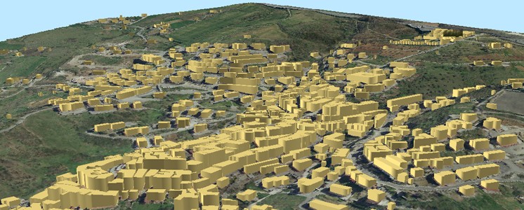


- Volumetric 3D model of a urban centre
- Point cloud 3D model of a hospital
- Coloured point cloud 3D model with aerial images
- Detail of a point cloud 3D model of a urban area
- Point cloud 3D model of Piazza Prefettura in Potenza
- Laser Point cloud 3D of a historical street in Potenza
- Terrestrial 3D laser scanning of Piazza San Gerardo in Potenza
- 3D point cloud of historical buildings
- Coloured 3D quota point cloud of Torre Guevara in Potenza
- 3D point cloud with photographic texture of Torre Guevara in Potenza
- Detail of 3D point cloud with photographic texture
- 3D point cloud of a historical Roman bridge
- 3D point cloud of a historical Roman bridge
- 3D point cloud of a historical Roman bridge
- Point cloud with photographic texture of a Roman bridge
- Tridimensional reconstruction of Monte Serico Castle
- Outlook of the virtual model of Monte Serico Castle
- Poligon Mesh of the Throne Room of Museo di Melfi
- 3D Model of the Throne Room of Museo di Melfi
- 3D Point cloud with photographic texture of the archaeological excavations of Grumento
- 3D Point cloud with photographic texture of the archaeological excavations of Grumento
- Laser 3D point cloud of a railway
- Point cloud with photographic texture of a railway corridor
- Point cloud with photographic texture of a railway corridor
- 3D point cloud model with photographic texture of a coastal section
- Point cloud with photographic texture of a road corridor
- Colour 3D Model of Stromboli
Software e App
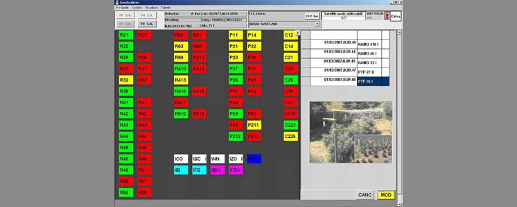


- GEOANALYZER software for the acquisition of georefferd images
- GEOVIEWER software for the simultaneous display of multi-source data
- SLIDE software for the analysis of movements by satellite data
- SLIDE software for the analysis of movements by satellite data
- Stereoscopic rendering of a highway corridor
- Stereoscopic rendering of a highway corridor
- Stereoscopic rendering of a highway corridor
Web GIS
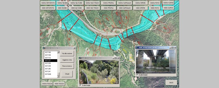


- WebGIS of a river
- Overlapping of layers in a WebGIS for the management of hydrogeological risk
- Overlapping of layers in a WebGIS for the management of hydrogeological risk
- Overlapping of layers in a WebGIS for the management of hydrogeological risk
- Layer of GIS for the urban requalification of Campobasso
- Layer of GIS for the urban requalification of Campobasso
- Layer of GIS for the urban requalification of Campobasso
Geo-referred videos