GEO Artificial Intelligence | Artificial intelligence applied to automatic pattern detection on high-resolution images and automatic classification of LiDAR point clouds

GEO AI

The research and development project “Geo AI” involves a qualified team of experts working on different fields of application that aim to link artificial intelligence to Earth observation in a completely original and innovative way. The paradigms and workflows in the trial phase, which have been confirmed based on models known in literature and adapted to specific needs, aim to meet different market needs. In particular, the Geo AI platform will enable us to carry out automated analyses of environment and infrastructure monitoring and control. Data and image learning and automatic recognition will make it easier for operators to quickly identify geometries, network elements (such as cables and supports) and problems, in order to draw up detailed maintenance and emergency plans. The automatic detection of anomalies through the development of machine learning algorithms is crucial to enhance network security and environmental protection, granting customers a further improvement in service delivery times and cost benefits. The software will allow us to completely automate some processing methods, such as the classification of the point cloud coming from laser scanner surveys. The project also deals with another delicate issue, which has been the focus of a wide debate in recent years: privacy. In order to comply with (and increase compliance with) the GDPR in force, Geo AI will offer quick and effective solutions for data protection through image anonymization, always ensuring the highest resolution and quality.

Time Period: 2021 - In progress

GEO VEGETATION MANAGEMENT | Process automation and predictive analysis in the context of Vegetation Management near power lines

GEO VM

Efficient and constant asset management is essential to the success of utilities. This becomes even more critical when the assets concern power lines threatened by excessive vegetation growth. In fact, vegetation is the main cause of interference and damage to the networks.

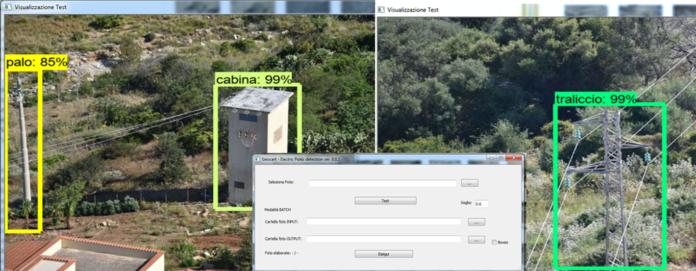
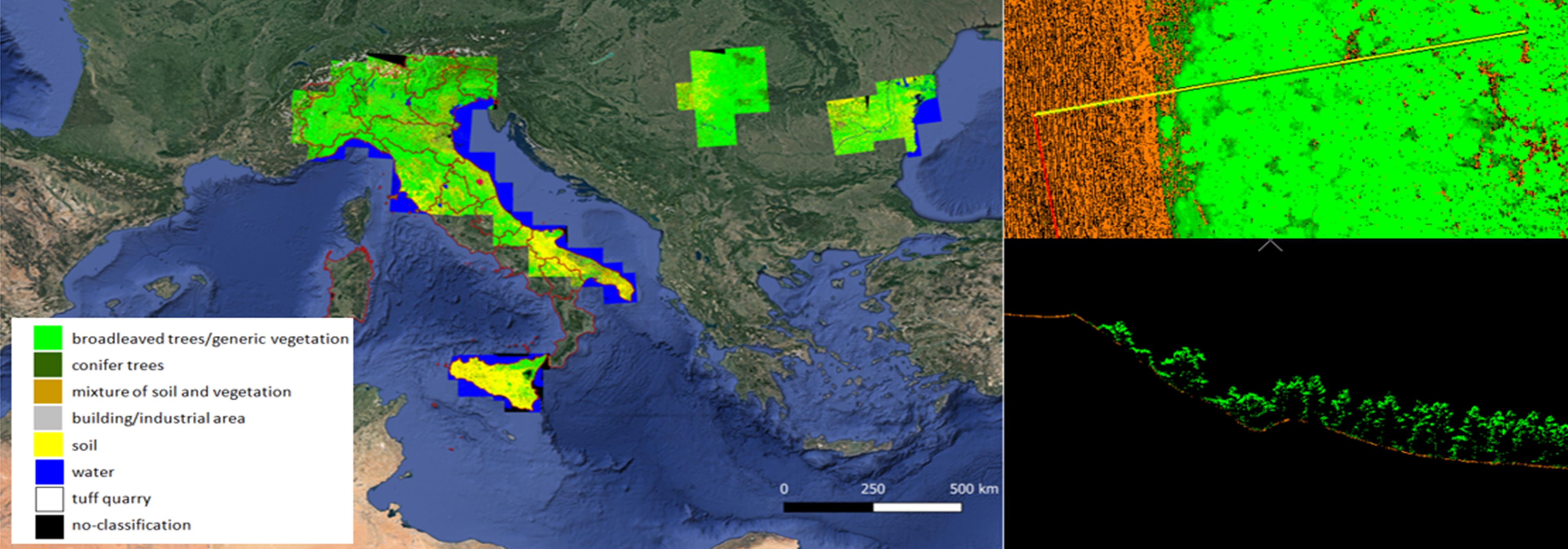
The GEO VM research and development activity starts from this insight, with the aim of developing automatic analysis procedures of trees' interference based on the use of multi-source data, remotely detected by aircraft and satellite. The project uses a software platform which, through artificial intelligence algorithms, analyzes lidar data, ortho-photos, and multispectral satellite images, providing regular and accurate information on the state of vegetation in the vicinity of the infrastructure. In addition to the automatic detection of high-risk points, the tool will include several features that enable us to perform a detailed predictive analysis. For example, GEO VM will automatically calculate growth rates for each classified tree species, and assign priorities and associated cost estimates, to ensure more aware management of infrastructure monitoring activities and activate timely and constant control, even remotely. The rationale behind the project, therefore, is offering customers a valid tool supporting decision-making processes, to reach a perfect balance between effectiveness and efficiency: maximum service reliability combined with maximum resource savings. Therefore, this program will help avoid disasters and service interruptions, predict, and determine ex ante missions, as well as optimize workloads and revenue streams for the benefit of health and safety. The know-how gained in the field of the Vegetation Management on power lines will be transferred to other strategic services related to infrastructure monitoring, which is an increasingly crucial topic, which Geocart has decided to aim for.

Time Period: 2019 - In progress

SLIDE S1 | Monitoring of land changes from satellite data: millimeter shifts (SLIDE S1) and changes in ground coverage (Change Detection) caused by natural and anthropogenic events

SLIDE S1

In urban areas and infrastructure, satellite techniques using SAR (Synthetic Aperture Radar) data with a multi-image approach enable the continuous surface deformation phenomena to be detected with pinpoint accuracy.
On this subject, research efforts have focused on the development project “SLIDE S1”, a continuation of SLIDE (Sar Land Interferometry Data exploitation), a Geocart's proprietary technique for assessment of surface shifts using SAR satellite data. Developed in 2005 to use ERS satellite data, it was then adapted to use COSMO-SkyMed data. The new SLIDE S1 version was launched in 2019 following the launch into orbit of the Sentinel-1 satellites within the Copernicus European Environment Program (2014 and 2016). Thanks to the new input data system, it ensures higher levels of performance. The Sentinel-1's open data acquisition policy and the increased frequency of new data interpretation make it easier to validate data processing procedures and continuously monitor faster motion trends with up to 6 days of measurement updates (every 6 days a new image is acquired which allows a new displacement measurement). Tests can then be validated with greater continuity and accuracy. In addition to the development through differential interferometry, Geocart is creating sophisticated change detection techniques, based on the integration of various kinds of satellite data (SAR and optical multi-spectral images) to detect local transformations (caused by changes in land use or natural disasters such as landslides, floods, fires, avalanches).

Time Period: 2019 - In progress

This site does not use any cookie profiling.On this website we use only technical cookies.
Cookies are used by third parties related to the presence of "social plugin" , Youtube's video embedded,Google Maps. If you continue browsing, you accept the use of cookies
Should you need further information about the use of cookies on the site and read how to disable the use, please read our extensive information about the use of cookies.