ARES | Autonomous robotics for the extended ship

Ares

The ARES Research and Development project,funded by MIUR under the PON Research and Innovation Program 2014 and 2020 - PNR 2015-2020 - "Blue Growth" Specialization Area and coordinated by the National Research Council in collaboration with other industrial and research partners, intends to develop a new paradigm in the field of marine technologies: a complex system, the ship with all its subsystems (control, measure, etc.), integrated with new marine robotic technologies (i.e. a cooperative system of underwater and surface drones), to extend its flexibility of use and mission and to make it operational in several areas including emergency interventions for environmental disasters, support for the Defense system, installation and maintenance of facilities for energy extraction from the sea, offshore platforms, etc.

The project aims to increase robotic research by fueling a substrate of SMEs capable of developing robotic vehicles, instrumentation and marine sensory, ICT systems, data analysis and management, control and remote supervision.

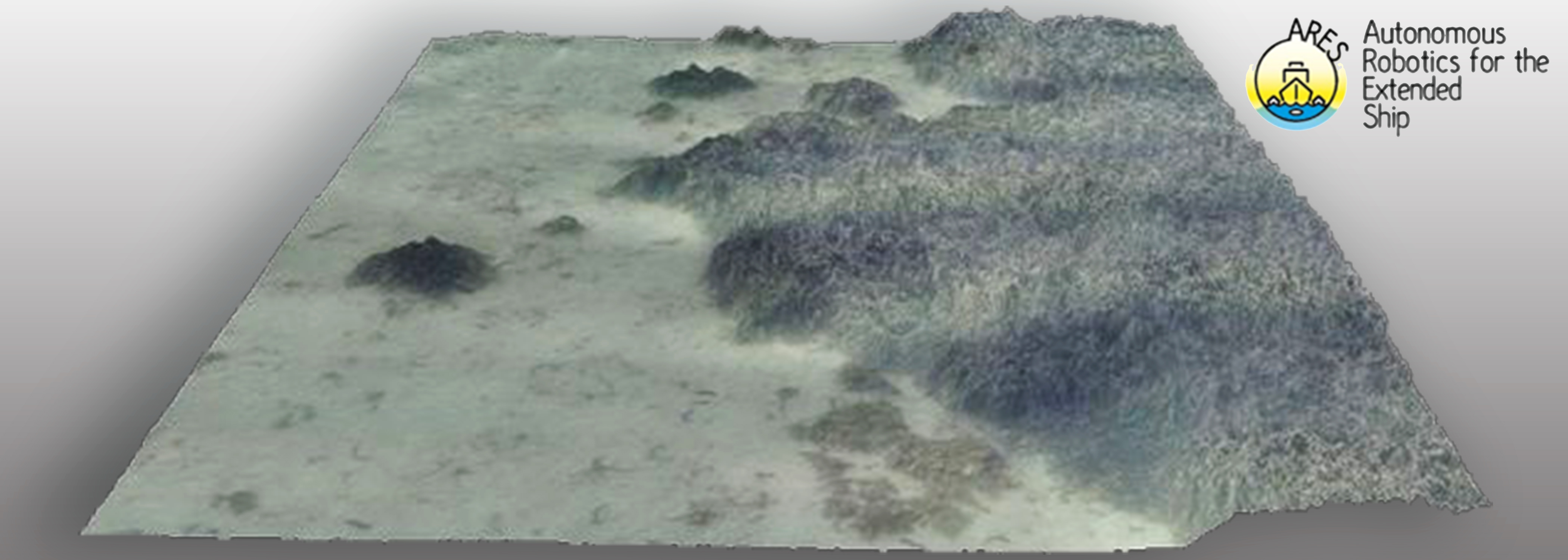
Geocart, in particular, is researching and developing an advanced methodology for the reconstruction of complex submarine environments and structures through the multimodal aggregation of data acquired by other project partners and from optical systems (underwater cameras) and sonar systems (Side-Scan, Single-Beam, Multi-Beam) for the generation of seabed DTM (Digital Terrain Model) maps, along with orientation data and position of the acquisition platforms.

Project Partners: National Research Council (Lead Partner), MAR.TE. S.C.A R.L., MAR.TE. S.c.a.r.l. , University of CALABRIA, Next Geosolutions Europe S.p.A, Seastema S.p.A, DIAMEC Technology S.r.l, Geocart S.p.A, University Consortium for Socio-economic Research and the Environment (CURSA), University of PALERMO, Apphia S.r.l, University of GENOA, University of ROME "La Sapienza", University of BOLOGNA.

Time Period: 2019 – 2022

OT4CLIMA | Innovative Earth Observation (EO) technologies to study Climate Change and its impact on environment and territory

OT4CLIMA

The overall objective of the OT4CLIMA project, funded by MIUR under the PON Research and Innovation Program 2014 and 2020 - PNR 2015-2020 - "Aerospace" Specialization Area, is to develop new measurement tools and new Earth Observation methodologies to provide products/applications/services aimed at improving mitigation capabilities of the effects of Climate Change (CC) at regional and sub-regional scale.

The project is based on the awareness that the environmental and territorial impacts of the ongoing CCs need to be better understood, modeled and observed, even at the local and regional scales in order to implement appropriate and effective mitigation strategies. It responds to some of the outstanding challenges identified by major international initiatives (e.g. CEOS WG Climate, GCOS) as Recommendations and Actions for the coming years, such as the use of new observation technologies, observation of additional climatic parameters as well as the development of new analysis techniques (cf. GCOS 2016 Implementation Plan).

OT4CLIMA, without claiming to address the problem as a whole, intends to contribute to specific phenomenological areas (water and carbon cycle), parameters, observables, and environmental matrices.

Specifically, both medium- and long-term impacts (e.g. vegetation stress, drought) and extreme events with rapid evolutionary dynamics (e.g. intense weather conditions, fires) will be investigated in an attempt to achieve dual technological, "product" and "process" innovation.

The project, for instance, will make concrete the possibility to measure, in an unprecedented manner and accuracy, both atmospheric parameters (e.g. Carbonyl sulfide (COS)) and surface parameters (e.g. soil water content) essential in determining the vegetation contribution to the CO2 balance, while proposing solutions based on analysis and integration of observation data acquired by satellite, airborne, and unmanned platforms to significantly improve the ability of local communities to address the effects of CCs in short- and long-term.

Particularly, within the framework of the realized objective of advanced EO methods for the study of short-term climatic impacts as well as quantitative characterization of fires, Geocart is working on research and development of methodologies that are as automated as possible and, based on application of lidar data, for the estimation of available pre-event biomasses. The study area is the Ionian coast of Lucania, where Geocart has a database of lidar and optical multi-temporal data acquired with airborne platforms.

The project team consists of a solid public-private partnership with a strong presence in the European and national research and innovation system in the Aerospace sector.

Project Partners: National Research Council (Lead Partner), CREATEC Scarl, SIIT S.c.p.a. Technological Integrated Intelligent Systems, University of TRENTO, Italian Space Agency, SURVEY LAB S.r.l., CO.RI.S.T.A. - Research COnsortium on Advanced Telesensor Systems, National Institute of Geophysics and Volcanology, University of CALABRIA, e-GEOS S.p.A., I.D.S. - SYSTEM ENGINEERING S.p.A., University of BASILICATA (UNIBAS), CIRA S.c.p.A. - Italian Aerospace Research Center.

Time Period: 2018 - 2021

OT4CLIMA

AOSTA DIGITALE | Innovation for history

AOSTA DIGITALE | Innovation for history

The Aosta Digitale Project, selected as part of the pre-commercial contract promoted by the Single Central Commission of the Autonomous Region of Valle d'Aosta for the enhancement of cultural heritage, provides an interactive discovery and fascinating itinerary of Aosta City where access to cultural heritage coincides with the experience of exploring, investigating and understanding of the re-connected sites in an innovative report that does not renounce the scientific value of information, but rather declines in an informative format for a broad audience.

Aosta Digitale offers two tools to end-user: a video game (an interactive application developed according to the principles of gamification to explore Aosta remotely) and the “Interactive Map” application, which serves as a "compass" and "magnifying lens” to move around Aosta and learn about the city's main cultural beauties even following suggestive thematic routes.
The two instruments, one serving as a spin-off to the other, are linked by the same plot, a true emotional exploration engine, inspired by William Brockedon's Travel Journal, published in London between 1828 and 1829 with the title “Illustrations of the Passes of the Alps, by which Italy communicates with France, Switzerland and Germany”.

The video game tool is intended to remotely build an affectionate and curious atmosphere around the city in order to entice the visitor to continue the discovery by physically reaching Aosta. Once arrived, with the help of the interactive map, the user will be able to navigate the sites of interest and access to "augmented" information that will make the path a unique experience.

The “Interactive Map” application is the exploration engine; the discovery of the cultural treasures the city embraces is ensured through access to various features and application of interactive content. The three applied technologies include: Inter-connected Augmented Reality, Immersive Virtual Reality and 3D Audio.

However, technology is just the medium that sustains conducting the journey of discovery, not the end.
The ultimate goal is to learn about Aosta through a comprehensive discovery route in which the traces present in various sites intertwine in a unitary vision of the city.

Project Partners: Geocart S.p.A. – Effenove s.r.l.s.

Scientific Project Manager: Archaeologist Giordana Amabili

Research Consultant: Department of Mathematics, Computer Science and Economics (DIMIE) of Basilicata University (UNIBAS)

Time Period: 2019 – 2020

This site does not use any cookie profiling.On this website we use only technical cookies.
Cookies are used by third parties related to the presence of "social plugin" , Youtube's video embedded,Google Maps. If you continue browsing, you accept the use of cookies
Should you need further information about the use of cookies on the site and read how to disable the use, please read our extensive information about the use of cookies.